
Why write a blog?
Lots of people think that crazy adventures like this are for 'proper cyclists'. Well let us assure you that we are not that! A few people contacted us during and after our trip with some common questions, so we thought we would write a blog if that encourages others to take the leap and plan a cycle adventure following route NC500.
Common Questions:
Did you do much training?
Could I get lost?
Do I need a tour group or can I do it alone?
How hard was it?
Is there phone reception?
What did you take? How much did you carry?
Can you get cash out whilst there?
How cold was it?
Did you cycle the Bealach Na Ba?
We will attempt to answer these questions throughout this blog post, and if you still have any unanswered questions- please get in touch!
Pre-cycle preparation:
I started triathlons last year so would say I have a medium-high level of general fitness, but I am stronger in the swim and run than the cycle. The furthest I had cycled in one go was 65 miles before coming on this adventure, and this was without many hills or carrying pannier bags. I felt relatively prepared and had maintained winter fitness with 1 spin class a week at the gym as well as a longer cycle at the weekend.
My cycle buddy Claire wasn't quite as prepared! Full of good intentions, she planned weekend cycles but accidentally woke up hungover and missed a few of them.. so with all the will in the world, working a job with long hours and little motivation to train during winter she embarked on this journey having just done 1 spin class a week, and occasional weekend cycles, but these were usually flat and at a leisurely pace.
We started planning our adventure in January. Bought a road map and a highlighter pen, we looked at the route, tried to find blogs online (only found 1!) and booked accomodation. Our thought process behind going over Easter was that Easter break is usually quite good weather, plus it was less likely to be busy. There is limited accomodation up North so during tourist season it is imporotant to book in advance!
 |
| Route and distance planning |
Packing List:
I had a cyclocross bike, and Claire had a road bike. Both had on a pannier rack and pannier bags (see photo below).
We each took:
- 4 x spare inner tubes (no cycle shops en route!)
- homemade flapjack, breakfast bars, energy gels, dried fruit
- 2x cycle shorts/ 3/4 trousers
-2x cycle tops
-1x cycle jacket
-1x cycle waterproof jacket
-1x leggings and top for evening
-1x trainers
-2x porridge pots (for accomodation that didn't include breakfast)
-2x Buffs (1 for neck and 1 for head on Bealach Na Ba day this was useful for hailstones at the top!)
-1x fingerless gloves, and 1x winter cycling gloves
Journey up to Inverness:
So we decided to start at Dingwall instead of Inverness since there
is no official start point, and that road from Inverness is not known to
be the most scenic! A friend put us in touch with a contact that
advertises on Air B&B, so we stayed here.
Lovely
friendly host and gorgeously remote farmhouse made for a good first
night with a great view of the stars. Note- there aren't many places to
eat near here, so we stopped off at Pizza Express in Inverness first
before coming here. We also took our own porridge pots so all we needed
was some hot water and a coffee and we were ready for a quick getaway in
the morning.
 |
| Accomodation in Dingwall- 7am and we're off! |
Day 1: From Inverness
(or in our case Dingwall) to Lochcarron
Distance: 48.1 miles/ 77.4km
Time taken: 4h29 (plus photo and snack stops)
Speed: avr. 10.7mph/17.22kph
Elevation Gain: 1,210ft
Route description: Lovely easy introductory day, not too hilly and v. scenic :)
We started from Lochussie at 7am, pushing our bikes down the gravel track to the main road (A835)- didn't risk cycling as we didn't fancy a puncture in the first 5 minutes! Once on the main road we quickly got into a cycling rhythm, the road was deserted at that hour and the scenery was beautiful: forests, valleys and low lying cloud. Loch Luichart was on our left between A835 - A832- it was stunning!
25 miles/ 40km in we reached Achnasheen. The blog we found online recommended stopping here for lunch- it is tiny!!! There was one coffee shop, which apparently had been closed for years! We were so disappointed! Instead we took shelter in the bus stop and ate some homemade flapjack that I brought (best thing ever- see link below if you do this cycle, we relied heavily on these during the day!)
 |
| Taking shelter in the bus stop (toilets there too!) |
As a side note- we did spot a hotel on the way out of Achnasheen so I reckon you could get a cuppa there, but it was too late for us we were ready to get back on the road!
The second half of the journey was a bit tougher, more open road meant stronger headwind, so we slowed down a bit here. The final 5-8 miles coming into Lochcarron were calmer winds and mainly flat/ downhill- a lovely way to end the day! We stayed in Loch Dubb B and B, which was GORGEOUS, lovely friendly hosts and amazing views of Lochcarron from the house. Plus a helpful husband that helped us sort the bike seat out. Dinner at Lochcarron Hotel- just what we needed.
 |
| Day 1- second half, open blustery roads |
Day 2: From Lochcarron
to Kinlochewe
Distance: 61.6 miles/ 99.2km
Time taken: 5hours 38 minutes(plus photo and snack stops)
Elevation Gain: 5093ft
Route description: Very hilly and challenging day!
So we set off at 7am, nervous for the hills ahead of us. We only heard of the Bealach Na Ba a week before setting off on this adventure- "The greatest ascent of any road climb in the UK" . It was about an 8 mile cycle to the start of the Bealach, where we got our tourist photo and had a shot of energy gel as a last hope to power us up the hill. Laden with our pannier bags and on a cyclocross bike, we were already making excuses ;) This road is famous for its hairpin bends, and rightly so! Tackling a hill must be done so at one's own pace, so we both agreed to cycle solo and meet again in Applecross at the Walled Garden Cafe.
 |
| View from Loch Dubb B&B at 7am when we set off |
| At the foot of the Bealach Na Ba |
First half to Applecross (including
Bealach Na Ba) 19.7 miles,including around 6/7 miles of solid uphill climbing. I managed to cycle it all, but Claire walked and pushed her bike up a lot of it. It was good to go at our own pace as we knew we would meet in a lovely cafe after! DO IT!! Would be my advice, I love a challenge and the views were great. Plus the feeling flying down the other side was like no other. Claire, however, would disagree, she hated the huge climb, as do others... so ultimately you decide! If you do decide to do it, make sure you include hill climbs when you're preparing for this adventure. Although be warned, even though the day started off with blue skies and sunshine, the route is so high it was hailstones, wind and rain at the top.
 |
| Almost at the top of the Bealach- sun trying to get out! |
|
|
|
|
| We Made it! Walled Garden Cafe in Applecross- sausage sarnies and drying off by the fire was BLISS! |
|
|
The afternoon cycle was BEAUTIFUL. Undulating path right along the coast. Stopped in Shieldig for a toastie then continued for last 20 miles to Kinlochewe. Flat roads at the end made for a lovely finish- see pic below.
Applecross to Kinlochewe was 41.9 miles. Had a celebratory red wine on arrival with a nice family that we met in the Applecross cafe at lunch today. You will find that you see the same faces throughout this route as lots of people were driving it! Since this family were travelling the same route they offered to carry Claire's pannier bags for the afternoon which was super handy. Cycling on your own? No worries there you will never meet friendlier people- both the locals and tourists were incredibly friendly and helpful offering to carry bags or offer support!
Day 3: From Kinlochewe to Ullapool
Distance: 73.3 miles/ 118km
Time taken: 6 hours 6 minutes (plus photo and snack stops)
Elevation Gain: 4427ft
Route description: Hilly and challenging (poor weather didn't help!)
Set off at 7am and made it to Gairloch by 9am (18 miles), intended on stopping for a coffee here but coffee shop didn't open until 10, so kept cycling to Poolewe (another 7 miles). We stopped at the first cafe we saw (on the left as you come into Poolewe but can't remember the name!). We were SOAKING wet at this point as it had been raining since we woke up. A lovely spanish couple owned the cafe and were very welcoming when we stripped off our dripping coats and dried them by the fire.
| Claire drying her bum by the fire! |
After drying out by the fire we set off again. We quickly split up as it was wet and windy so it was important to go our own pace. 45 Miles in and I spotted a sign for Maggie's Tearooms- what a blessing! I waited 45 minutes then got a phone call from a landline- Claire had been so cold and wet that she stopped in at a local's house for a cuppa! Luckily we realised that she was only 2 miles behind me so quickly joined me at the cafe. But again, another example of how kind and friendly the locals are! There is little to no phone signal, and nothing between these stops named so there is little shelter from brutal wind and rain on these long days- be warned!
The final 27 miles was a tough slog, the longest I had ever cycled in 1 day (75 miles) with hills plus terrible weather. I love a challenge though, so managed to power through. As I was coming into Ullapool, a campervan passed me and beeped- as I glanced to the side I spotted a grinning Claire, happy as larry, hitching a lift for the last bit! haha! We laughed so much that evening. A ridiculous day for 2 novice cyclists and desperate times really relied on the friendly nature of local people and tourists road tripping. Following about an hour in the dry room in the Ullapool Youth Hostel, we ventured out for fish and chips then got an early night. Really recommend this youth hostel, it was great for cyclists and there was alockable storage room. Plus other cyclists were staying too so it was a good place to exchange stories (turns out we had been the only cyclists mad enough to cycle that day)...
| Afternoon passed by some lovely beaches, but drizzle meant quick stops only |
Day 4: From Ullapool to Kylesku
Distance: 33.3 miles/ 54km
Time taken: 3 hours 15 minutes (plus photo and snack stops)
Elevation Gain: 2526ft
Route description: Short and hilly but lovely!
Today we set off a little later because we got up, ready to go, then realised that reception didn't open until 8am and the receptionist had the key for the bike storage! So remember this if you stay here.The first 26 miles took us to the crossroads where we needed to decide whether or not to go the longer route to Lochinver. The morning was beautiful, lots of hills and countryside and quiet roads, but we decided to miss out the extra bit to Lochinver as winds were 20-40pmh and our legs were tired. Stopped at some castle ruins to enjoy the views, and from there it was only 7 miles direct to Kylesku so we decided to do that rather than take the coastal path.
It was VERY hilly and windy though. I found those last miles tough! The first half was a 3 mile climb and the wind and hailstones made it a tough mental challenge. The downhill on the other side was beautiful. One winding path through moorland.
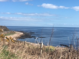
Coming into Kylesku the sun broke through clouds and it was stunning (see below)
Found the Kylesku Hotel and those hills were worth it! This was our FAVOURITE place to stay, and was a lovely treat after the 2 long days of cycling to get here by 12.30pm with a full afternoon to enjoy the lovely hotel. Ordered a bottle of wine and chatted whilst overlooking the loch. Hotel was a lovely treat, and the seafood was incredible- highly recommend staying here!

Day 5: From Kylesku to Durness
Distance: 38.5 miles/ 62km
Time taken: 3 hours 19 minutes (plus photo and snack stops)
Elevation Gain: 2311ft
Route description:Not too bad!
The 3 mile climb out of Kylesku was tough going, then it flattened out. Weather was a mixture of cloud and drizzle so we decided to give Kinlochberview a miss- so glad we did!

Arrived at Durness nice and early (12.30pm) after a lovely long stretch of single track lane (at one point I was zooming along at 33mph!) and the sun was shining.

Arrived at Durness Beach! |
 |
| Cocoa Mountain hot chocolate |
Durness beach was lovely, so we went for a little walk then headed over to Cocoa Mountain Cafe for a delicious hot chocolate.
We then checked into a B & B (doesn't have a website but was next
to the main hotel so we got in contact through that) then took a wander
to Smoo Caves (see photos below).
 |
| Smoo Caves |
| Dinner in Smoo Caves Hotel- best pie of my life |
Day 6: From Durness to Melvich
Distance: 55.2 miles/ 89km
Time taken: 4 hours 35 minutes (plus photo and snack stops)
Elevation Gain: 3746ft
Route description: Undulating but lovely cycle.
This morning was the most stunning of them all. As we left Durness the sun was shining, the road snaked around the coast and the view was as below:
The first 20 miles this morning were round Loch Eribol which was a lovely cycle if not a little windy. After this we arrived at Kyle of Tongue, which was gorgeous. The water was a lovely colour and we enjoyed cycling over here.
Coffee stop on the way out of Kyle of Tongue at Weavers cafe and craft shop, we loved it here, had a scone and a nosey round the nice touristy gifts in the shop attached.
Day 7: From Melvich to Wick via John O' Groats
Distance: 57.5 miles/ 92.5km
Time taken: 4 hours 10 minutes (plus photo and snack stops)
Elevation Gain: 2218 ft
Route description:Part 1: Melvich to John O'Groats= 37.3 miles, 2h31 mins. Part 2: John O'Groats to Wick= 20.2 miles, 1h37 min.
First half of today's cycle (37.39miles) was lovely. We flew down to John O' Groats with sunshine and tailwind (and a little bit of
hailstones after all it is Scotland)
After a 2 hour lunch stop eating
ALL the tray bakes and drinking all the tea we struggled with the last
20 miles to Wick with a strong headwind! Passed by Duncansby Stacks on way out of JoG which was v.scenic.
 |
| Duncansby Stacks |
Day 8: From Wick to Rogart (or Dornoch was the initial plan but we de-toured to stay with a friend)
Distance: 63.9 miles/ 103 km
Time taken: 4 Hours (plus photo and snack stops)
Elevation Gain: 3380 ft
 |
| Coastal Route |
Route description: 64
miles of gorgeous sunshine, incredible coastal and countryside scenery.
One AWFUL surprise hill at Berriedale, 1 mile of climb at 13% gradient!
Made up for it in the afternoon with a flat road and a visit to
Dunrobin castle in the sun. Evening by the fire with wine and cheese :)
 |
| Dunrobin Castle |
| Taking the back route to Rogart |
Day 9: From Rogart to Dingwall (or back to Inverness)
Distance: 44.9 miles/ 72 km
Time taken: 3 hours 24 minutes (plus photo and snack stops)
Elevation Gain: 1263 ft
Route description:Busier roads but flat so zoomed home in time for lunch
 |


 Coming into Kylesku the sun broke through clouds and it was stunning (see below)
 Found the Kylesku Hotel and those hills were worth it! This was our FAVOURITE place to stay, and was a lovely treat after the 2 long days of cycling to get here by 12.30pm with a full afternoon to enjoy the lovely hotel. Ordered a bottle of wine and chatted whilst overlooking the loch. Hotel was a lovely treat, and the seafood was incredible- highly recommend staying here!


 Coffee stop on the way out of Kyle of Tongue at Weavers cafe and craft shop, we loved it here, had a scone and a nosey round the nice touristy gifts in the shop attached.


It seems to have been a really good experience...
ReplyDeleteas I know some of the places, could imagine what you both were doing!!
amazing trip and effort!!!
Excellent write up. I enjoyed reading it. Thank you for sharing.
ReplyDeleteLovely write up. Thoroughly enjoyed reading. Husband and I are off to cycle the route on 20th July, mainly going to wild camp and take 9 days approx.
ReplyDeleteHave taken a lot of tips from your blog. Thank you for sharing
Thoroughly enjoyed ur blog & gave me great insight to the anticipated challenges of hills & weather. Wr doing it clockwise 1st week in September with 1st half same as yourselves but extending the daily mileage from kylesku
ReplyDeleteBring it on.....
Thanks for the write up, lovely to read and provides inspiration for our trip in September 2018. Congratulations to you both x
ReplyDelete